LUISENSTADT PERSPECTIVES
Sacred buildings under the tension of Berlin’s urban development around 1848
by Rolf Engelbart
It has been said that Berlin boasts more bridges than Venice and more churches than Rome. Berlin’s urban landscape today is indeed still dominated by the sacred buildings of the 19th century. Considering the number of church steeples rising out of the cityscape, the comparison with Rome may be bold but not entirely absurd; in many parts of Berlin, church spires form a central feature of the city streets and can often be seen for miles around. This impression owes itself above all to the churches built during the reign of Wilhelm II. They were usually erected at prominent points in the street grids, which had long been laid out and already partly built up. In this respect, the construction of the great Wilhelmine churches accentuated the logic and aesthetic of an urban plan, which reached out beyond the old Berlin and played a role in defining the boundaries and layout of the surrounding communities, which until 1920 were municipalities in their own right.
The major, yet entirely separate, factors for this development were the circumstances around the middle of the 19th century, when the catholic St. Michael’s Church, the protestant St. Thomas Church and the Bethanien hospital were planned and built – all within sight of a new canal with a significant number of bridges with a certain Venetian influence. If one can speak of an authoritarian-ecclesiastical redefinition of the urban layout in respect of the Wilhelmine churches, then the churches and hospitals built in the Luisenstadt area were an integral part of the town planning right from the start, strategically placed at dominant points in the street grid, rather than an after-thought. At the same time, the period during which they were built was a time of contradiction and publicly waged economic and political conflicts. A romantic-monarchical image of town and country versus land speculation, the idea of the church’s healing power versus the reality of the emerging proletariat, a reclaimed divine right versus the people’s revolution and within all of this, the hardship of unemployment versus the established need for order and predictability.
In order to explain the context of these buildings as a historical landscape, certain methodical and historical prerequisites need to be laid out. One must consider the urban, architectural, religious and political perspectives during the period around 1848, and the ways in which they cross and interweave and tie in with the dominant ideas of urban development and church policy.
Urban development
From the 1730s, Berlin was enclosed by the Akzisemauer or ‘excise wall’, which was built not so much for fortification but rather for fiscal purposes and to prevent the desertion of soldiers from the highly militarised city. To the north-west and south-west of the city, the wall lay close to the edges of the Baroque city’s expansion, whereas in the east, which was more strongly characterised by farming, the wall surrounded partly privately-owned land and partly the Feldmark (fielded areas which were available for public use such as livestock grazing). The largest of these areas within the city wall was the Köpenicker Feld, which stretched out towards its namesake, the town of Köpenick. The wall enclosed a large urban reserve about the size of Tempelhofer Feld, Berlin’s disused airfield, the development of which was rejected in a recent public referendum.
The Stein-Hardenberg reforms in Prussia ushered in the abolition of serfdom and thus allowed for the free movement of the rural population from 1810 onwards. This led to an increased influx of people, at first mainly in the northern suburbs of Berlin. It also brought about land speculation with the introduction of mass-accommodation. In the southeast, this development was less obvious, though foreseeable, and, faced with that large interurban space the Prussian government and the municipal authorities took on the development of the Köpenicker Feld in the 1820s as a town-planning project.
In 1826, Johann Carl Ludwig Schmid, a close colleague of Schinkel, submitted a plan for the development of the field to the King, who subsequently approved the proposal. Already at this time, the plan envisaged an expansion of the urban area beyond the Akzisemauer reaching out to the Landwehrgraben. Due to numerous difficulties relating to pre-existing land laws and the ongoing division of the Feldmark into private ownership (the so-called separation), the proposal was not implemented as planned. However, it did pave the way for subsequent urban development, in particular the canal, whose purpose was to bring drainage and economic development to the area.[1] Development was accelerated by the accession of Friedrich Wilhelm IV in 1840 and the appointment of his landscape architect Peter Joseph Lenné to the job of continuing the plans. When it came to architecture, the King was more than just a dilettante: as Crown Prince he had already worked closely with Schinkel and Lenné and liked to think of himself as an architect only prevented by birth from entering the profession. A sketch of an idea for the Köpenicker Feld drawn up by the King dates back to as early as the 1830s. It includes a radial square, a large intersection inspired by the Place de l'Étoile in Paris, as well as a curved stretch in the canal - a deviation from Schmid’s clear and straight lines. Lenné introduced the King’s ideas directly into his first draft, though he soon combined them with the main features of Schmid’s plan, which were better suited to the existing or soon to be created structures of ownership than the King’s idea of a radial square.
Lenné's plans for the area were related to his overall plan for the embellishment of avenues crossing and surrounding Berlin (what he described as “Schmuck- und Grenzzüge von Berlin und nächster Umgebung”). The origins of his designs lie in the landscape architecture of Romanticism. Elements of embellishment, characteristic of the court aristocracy, were transferred to the more bourgeois sphere of urban development. In this an act of transferring, however, lies a dialectic moment. In Lenné’s comment on his project for the whole of Berlin, he mentions the importance of recreation for the people of the city in gardens and promenades: "Throughout the project in hand, it has been my intention to distribute the given space so that the community may not only find use in the new facilities, but that the residents may also fulfil their right to pleasure in doing so. Because the further a nation progresses in its culture and in its prosperity, the more manifold are its sensual and spiritual needs. This includes public promenades, whose creation and reproduction in a city must not be recommended for pleasure alone, but also also with health considerations in mind.”[2] The initial design intent, motivated purely by aesthetics in its original courtly context, is suddenly related to civilisation and hygiene.
Lenné's overall plan for Berlin retained its patchwork character, partly due to the need for space for the construction of railways. Its main features, however, were included in the development plan of 1862; and to this day Lenné’s design for the layout of Luisenstadt still significantly characterises the area. With the formation of Greater Berlin and the district boundaries, the term ‘Luisenstadt’ has now disappeared from the map. A small section of Luisenstadt was submerged by the district Mitte and the larger part joined the newly-formed district of Kreuzberg. Its name originates from 1802, when the residents asked to rename their part of the city (then the Köpenicker Vorstadt) after Queen Luise. Formerly a rural area inside the Akzisemauer with approximately 10,000 inhabitants, it grew into one of the most densely populated parts of Berlin over the course of the 19th century, with over 300,000 inhabitants on Lenné's layout.
From the middle of the 19th century, these generously sized city blocks became particularly densely built up by a mixture of residential buildings, workshops and factories. This mixture, known today as the “Kreuzberg mix” of residential and commercial buildings has always been characteristic of Luisenstadt. A much stronger influence than the division of city districts were the border between the political sectors and the Berlin Wall, which ran in part along the canal and resulted in the gradual forgetting of Luisenstadt as a historic district in its own right.
Church politics
With the introduction of the Reformation by Elector Joachim II, and in accordance with the principle “cuius regio eius religio”, the area known as Mark Brandenburg became purely Lutheran territory in 1539. Practising the Catholic religion was prohibited; the only exceptions made were in the delegations of Catholic powers in Berlin. Only in territories that were later attached to Brandenburg and whose population was mainly Catholic, was public worship tolerated. It was not until the first half of the 18th century that there was a relaxation in the law in Brandenburg, though without any fundamental change. This relaxation was due mainly to the militarisation of Brandenburg-Prussia: freedom of religion was guaranteed for those recruited from Catholic countries to work as soldiers or skilled workers in armament factories.
Fundamental change only came with the accession of Friedrich II in 1740 and the conquest of Silesia, with its half a million Catholic residents. The King granted compulsory free practice of religion and had the representative Catholic Hedwigskirche in Berlin erected; not only to demonstrate his enlightened concept of the state, but also to keep a hold on the Catholic nobility of the new province, which still tended to favour Austria.[3]
To fully understand the political developments within the church in the 19th century, it is important to know that, in addition to the state’s attitude towards the Catholic Church, the dynasty of Hohenzollern had already converted from the Lutheran to the Reformed faith in 1613. In light of the largely Lutheran population, the Hohenzollerns renounced the general enforcement of the conversion but granted privileges to the reformed parishes in Brandenburg-Prussia. The inclusion of the Huguenot refugees further strengthened the Reformed church from 1685 onwards. Nevertheless, the disparity between the Lutheran majority and the Hohenzollern dynasty was perceived as a problem, leading to conflicts in the 17th century. King Friedrich Wilhelm III, who was in reign from 1797, tried to resolve this disagreement through the union of Prussia’s two protestant churches in 1817, the 300th anniversary of the Reformation.[4] Alongside his political and ideological interests as head of the church, historical factors relating to theology and religion also played a role here. With the Enlightenment and the emphasis of feeling and individuality in the theology of pietism and romanticism, the traditional dogmatic and liturgical differences between Protestant denominations had lost some of their significance.
By 1830, the Union was accepted by the majority, albeit with compromises. However a Lutheran minority refused to join it, particularly because of the difference in the holy communion doctrine between the Lutheran and Reformed traditions.[5] This conflict was further exacerbated by the Agendenstreit, the conflict over the Union order of worship introduced by the King in 1822, whereby he attempted to standardise the liturgy in all Prussian Protestant communities. On one hand, criticism of the King’s agenda came from the liberals, amongst others from Friedrich Schleiermacher, who, although he was an advocate of the Union, denied the King’s right to intervene in liturgical, if not in church affairs at all. Criticism turned into outright opposition, however, on the part of conservative confessionalists, in particular the Silesian Lutherans. The Old Lutherans, as they were later called, founded their own communities, although these were not recognised by the state and in part forcibly suppressed, resulting in turn to emigration to America. Prussia, which since the 17th century had stood as a country of immigration for Protestant refugees, had now become the country of emigration for orthodox Lutherans.
As King Friedrich Wilhelm III made extensive use of his rights as the head of the church, there was also a hardening on the Catholic side during the course of the so-called intermarriage dispute. This applied to marriages between Prussian citizens of Protestant and Catholic denominations. The conflict was triggered by the King’s enactment in 1825, whereby children from mixed marriages had to take on the denomination of their father. Until then, Catholic priests would only marry couples of different confessions under the premise that the children would be baptised as Catholic. Resistance began to grow, especially in the new, predominantly Catholic new Rhein province. It even resulted in the imprisonment of the Archbishop of Cologne in 1837, thereby causing a crisis in relations between the Prussian state and the Roman Catholic Church.
Both conflicts quietened down after the accession of Friedrich Wilhelm IV, who was well educated in theological matters and had already tried to work towards a solution during his time as Crown Prince. The intermarriage dispute was settled and the Old Lutherans were granted the establishment of an independent regional church.[6] The new King’s religious and political motivations were by no means liberal. Rather, they were theologically conservative and influenced by the revival of piety; but he understood his position less in terms of an absolutist government and more by one inspired by a romantic remodelling of the medieval doctrine of divine right in a sphere that rose above that of the confessions. Significantly, Friedrich Wilhelm IV was inclined to renounce his rule of the church but only in favour of a Protestant church led according to his own principles. Still, during its reign, the Prussian church was granted its own High Consistory in 1850. Until that point, its governing body was simply a department of the “Ministry of spiritual, educational and medicinal affairs”. It was characteristic of that time that the so-called ‘romantic on the throne’ should restrain his involvement in general church affairs but when it came to the details of individual parish matters and church-related institutions, particularly architectural issues, intervention on his part was commonplace.
Mariannenplatz
In Lenné’s planning phase, the development of the eastern part of Luisenstadt still seemed to be a relatively distant project. In the western part, development happened more quickly; already in 1875, the population density here was one of the highest in Berlin.[7] Thus, the obvious elements of urban planning are more concentrated in the western part. These are mainly the canal with Engelbecken as a juncture and Mariannenplatz with its elongated form. Although in 1890 the journalist Wilhelm Lösche could still look out onto meadows and farmland behind the construction site, he could also already notice the overpopulation of the areas around Mariannenplatz and the importance of its facilities: “How necessary this patch of grass is, the masses of children flocking together to play here provide proof of this, mostly poor children despite the elegant building facades, courtyard children with waxen complexions from the air in these courtyard dwellings, countless in their masses [...] And yet wouldn’t it be such a blessing if the whole of Berlin were built like this airy part of SE Berlin”.[8]
Named after a Prussian princess who had distinguished herself during the Napoleonic Wars with a patriotic proclamation, Mariannenplatz was supposed to compensate for the magnificent radial square proposed by the King in Lenné’s revised plan of 1840. Already included in the plans back then was a new Protestant church, initially planned to be built at the southern end and to be separated from the Luisenstadt parish. In subsequent plans, the church was moved to the northern edge of the square, not least because of the more picturesque location, with the back of the church looking out onto a bend in the canal. Today the elongated square, with its semi-circular southern edge, is still true to Lenné’s original plan. Its basic form harks back to the ancient Hippodrome. This motif had already played an important role as a formal element in Lenné’s plans for the gardens of Sanssouci. There the motif served as an accent of stately antiquity; here it served to create an urban open space. The internal division of the square with borders and lawns has not been retained. After the end of World War II, rubble and debris was used to elevate the square; its layout today dates back to the 1970s, and bears little resemblance to Lenné's plan, with one important exception, namely the two-lane avenue that surrounds the square. Rather than just a grassy space, the emphasis is on the encouragement of promenading and strolling. It is significant that the semi-circular edge of the square, so important to Lenné, led to persistent disputes with the landowners, who complained about the concave facades and the resulting irregularity of the floor plans.
The Bethanien Hospital
Once part of the home of deaconesses, the Bethanien Hospital was one of the earliest public buildings in this newly opened district. It was built between 1845 and 1847 according to plans by Ludwig Persius and owes its construction to the King’s own personal initiative, who may have hoped to add a little spark to the area. The architect worked closely with Friedrich Wilhelm IV on many architectural projects and was given the title “The King’s Architect”. Persius, however, died before construction began, and so Theodor Stein took on the task, in close collaboration with Theodor Fliedner, a clergyman from the Rhineland, who was particularly close to the King because of his combination of Inner Mission and social work within the church. The King adapted Fliedner’s model of a home for deaconesses, which he had founded in 1837 in Kaiserswerth near Düsseldorf. Their concept of welfare and nursing is ultimately based on revivalist theology, which combined personal piety with charitable service. Even under Friedrich Wilhelm III, this theological direction had already been promoted by appointments of revivalist theologians as professors at the University of Berlin. The concept for the deaconesses’ home also refers to medieval nuns working as nurses; as if to emphasise this, a medieval hospital is quoted on the facade. In the centre of the hospital, which originally housed 350 beds, there is a large galleried church, whose position is brought out in the main facade through its central projection and two turrets.[9] Underneath the church is the deaconesses’ refectory. With the founding of the hospital, the King turns the romantic image of medieval Christian society into one of modern welfare. Charity is considered an apostolic ministry belonging to the church, rather than a duty of the civil-communal administration authorities. In terms of the hospital’s interior design and technical infrastructure, it paved the way for Prussia and for its time; it was state of the art, particularly due to visits the executive architect had made to several hospitals across Europe. The novelist Theodor Fontane was employed here as a pharmacist in 1848/49.
St. Thomas’ Church
A new Protestant church had been part of Lenné’s plans for the square since 1840; but it was not until the 1860s that it was built according to a draft drawn up by Friedrich Adler, an architect from the second generation of the Schinkel school. Originally, the Luisenstadt community was responsible for the entire Luisenstadt or Köpenicker Feld; its church was destroyed during World War II and never rebuilt. With the development of the new quarters as a first step, a new parish was created in the west, separate from the Luisenstadt community. St. Jacobi Church was built for the new parish on Oranienstrasse 1844/45. With the King ’s financial support and participation in planning matters, the church was built in the form of a late antique basilica with a columned vestibule and a campanile. Even back then, separation to create another church parish was contemplated, but wasn’t brought about until the new city had been developed further. It was expected that the architecture of the church, initially proposed for the southern edge of the square, would lend itself to a place of worship for an urban parish with monumental external impact in the context of Lenné’s plan; it was also intended to be in keeping with that of the Bethanien hospital. The importance of St. Thomas for the construction of 19th century churches was already recognised by contemporary critics in the design Adler submitted for the architectural competition. It brings together the central space developed for the Protestant church in the 17th century with the longitudinal extension required by the contemporary theory of church building. [10] With the extension of the arms of the cross and the shortening of the nave, Adler found a solution that became a model for the great churches of the late Wilhelmine period. The monumental nature of the church is achieved through its lofty, narrow twin-towered facade, which carries the elongated shape of Mariannenplatz into the vertical dimension, so to speak, but even more so through the dome, which dominates the church and the cityscape in accordance with the loop of the canal along the axis of the Schillingbrücke. The church’s contemporary aesthetics asserted themselves against all practical considerations. Even in the planning phase, the effect the dome’s echo would have on the acoustics was already well known, in particular on the audibility of the sermon; in this respect, the church was a problematic case right from the beginning.
Due to the further densification of the Luisenstadt population, St. Thomas quickly became a church for the mass community. Already at the time of its founding, it counted 40,000 souls. In 1885 there were more than 100,000; furthermore, the five pastoral positions were also not always filled.[11]
The Luisenstadt Canal
St Thomas’ church stands with its chancel at the apex of a circular segment, delineated by the former Luisenstadt canal. The reference to water is in line with the basic feature of Lenné's urban design, which applied the concept of the picturesque, developed in romantic landscape gardening, to urban spaces.[12] As with the dome, the King ’s insistence on the loop in the canal meant that functionality had to give way to aesthetics. The small difference in water level between the Spree and the Landwehr canal resulted in a weak current, which was further slowed by the inclination between Engelbecken and the river Spree. Construction of the canal began in 1848, the year of Revolution, within the context of job-creation schemes. The emergency measures for recruitment of the unemployed began shortly before the March Revolution of 1848, as a futile attempt to prevent its outbreak. As a result, the progress of the canal’s construction was accelerated during the Revolution. In 1852 the canal was already open for shipping. In 1848, during construction, the October riots took place, caused by among other factors the remuneration scheme. Among the relief workers were unemployed craftsmen, who, in contrast to the more experienced, piecework labourers, preferred the daily wage, which was paid regardless of the amount of work that had to be done. On 16th October, a steam engine designed to draw water was destroyed by workers, who felt it was a threat to their jobs, comparable to the effect on weavers following the introduction of the power loom. Conflict arose between workers and the armed civic militia, who acted in place of the military to keep public order during the Revolution.
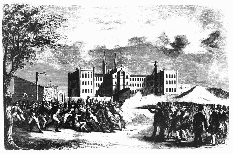
The shooting of canal workers by vigilantes as presented by the newspaper Leipziger Illustrirte Zeitung on 4 November 1848, with the headline: “Workers riot in Berlin on 16 Oct.” Whether the representation is based on eyewitnesses is questionable. The composition could also owe itself to the pictorial tradition of Goya's painting “The Execution of the Rebels” (1814). The scene of the action is however, consistent with the site; the rear facade of the Bethanien hospital, then highly visible with its distinctive church in the middle, speaks for the artist’s local knowledge.
Twelve workers and one member of the civic militia were killed. This bloody conflict between the civic-revolutionary forces and the canal workers, who were in turn divided into two camps, sealed the breakup of the revolutionary powers; finally, the militia’s monopoly of power was repealed in November with the reinvasion of the military.[13]
The canal’s purposes were the drainage of damp meadow land, the transport of building material for the new dwellings and the supply of food and fuel from the surrounding area to the local population. Even with its slow current, the canal was still able to fulfil its function of transportation, but it became more and more filthy and caused an unbearable odour problem in the area, particularly after the housing development had been completed and the lock in the river Spree was opened less often. The tree-lined promenades that Lenné had planted on either side of the canal could no longer fulfil their urban function as a “double boulevard”[14] within the context of an open recreational area. As a result, as early as the 1880s, filling in the canal was considered. This was then planned and executed in the 1920s, again as part of a job creation scheme; which, considering the canal’s evolutionary history, brings to mind the Sisyphus myth. The canal was filled with excavated earth yielded from the simultaneous construction of an underground tunnel.
In the planning phase, there was a consensus that the urban axis of the canal was to be respected. Instead of the canal, and along its course, a string of gardens was planned, which were to be broken up by dams where bridges once were. The design was rendered by Erwin Barth, a leading landscape architect, then horticultural director for Greater Berlin. He represented the reformist-inspired public park movement that was no longer content with receptive-aesthetic recreation, but firmly believed that games and sport should be integral parts of the parks. With this in mind, Barth first planned swimming baths in place of the Engelbecken, which was intended to be kept as an expanse of water. Within the different sections of the canal, he envisaged didactically-conceived “themed gardens”: for example, the woodland gardens which began at St. Thomas’ church and followed the curved canal course towards Engelbecken were not intended to exist purely as aesthetically landscaped gardens, but to bring people closer to the natural habitat of woodland planting. The creation of sunken gardens at the former water level and the addition of the parapets were used by Barth to clearly separate the sites from the street and in doing so, enhance their recreational value.[15]
Since 1920, the canal was also the border between the newly formed districts Mitte and Kreuzberg and therefore later became the boundary between the eastern and western sectors. After World War II, the gardens, along with Mariannenplatz were filled in with rubble; and as Lenné’s tree-lined avenues were felled and replaced by the Berlin Wall, the canal route became the death strip. After the fall of the Wall, an initiative was formed to restore Barth’s gardens. Reconstruction of many of the sites became possible. In addition to the actual garden areas, and following an idea of Edwin Barth’s, trees have been replanted in double rows in keeping with Lenné’s tree-lined promenades, which has been key in maintaining the overall impression of seclusion, despite the busy streets which flank the site.[16]
Engelbecken and St. Michael’s Church
Engelbecken and St. Michael's Church form the true heart of Luisenstadt as a late romantic urban landscape. The church was already included here in Lenné’s plan in 1840 to beautify the area and enjoyed particular attention from the King. On the one hand, the position of the church above the basin is decidedly reminiscent of romantic Italy; on the other hand, the prestigious construction corresponds to the ecclesial-political self-image of Friedrich Wilhelm IV, who dealt with the founding of the parish in the tradition of Friedrich II and sealed the end of the rift with the Catholic Church with a great architectural gesture. In 1845, the parish was separated from the Hedwigskirche, which was built under the initiative of Friedrich II, although the new church was initially used as a garrison church for Catholic soldiers, who had by now grown greatly in number. The period of the church’s construction, which was designed by one of Schinkel’s pupils, August Soller, lasted from 1851 until 1856. Along with the Bethanien hospital and the canal, the area around St. Michael now boasted yet another monumental feature. While Friedrich II had given the Hedwigskirche the subtext of tolerance, or even religious indifference, with its Pantheon-like architecture, the interior of St Michael’s Church leans towards the traditional Basilica, though with some characteristics of the Italian High Renaissance: the floorplan and dome are based on that of the San Salvatore church in Venice (built from 1508 onwards). The interior was considered one of the most successful of its kind in late-romantic church architecture; for Theodor Fontane, St. Michael’s was the most beautiful church in Berlin. It was in particular the flat domes borrowed from San Salvatore, instead of ordinary vaults, which added to the spatial impression by spanning the yokes of the nave and framing the raised copula to great effect; barrel vaults overarched the aisles. After the damage caused during World War II, only the transept, the dome, the chancel and the southern facade were restored. The nave and the aisles were preserved as ruins, and so the building is now more in accordance with early than late Romanticism aesthetics. Low functional buildings have been built on one part of the nave, though these are not visible from the outside of the church.
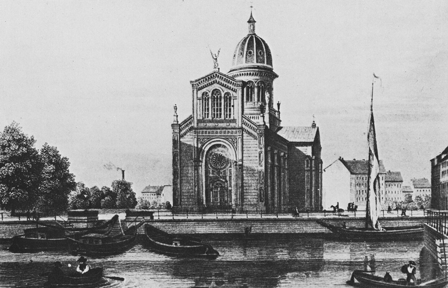
View of Engelbecken and St. Michael's Church. Lithography from after 1860, probably based on a drawing by F. A. Borchel. The impressive shadowing on the church facade is not caused by any actual object; the boat’s sail and flag in the right half of the picture are also likely to have been added as aesthetic embellishments. The image was in print at least until the 1880s, e.g. as a steel engraving, where the sailing boat is present, but the buildings in the background of the church have grown impressively in size.
Unlike in most Protestant churches, Catholicism had not experienced a break in the liturgy since the Middle Ages; and so the architect could move all the more freely when it came to designing the layout of St. Michael’s, drawing on the form of the elongated aisled basilica.
As with St. Thomas, the urban dominance of the church is accentuated by a high central dome, which also serves to compensate for its lack of a spire. Again, a twin-towered facade was planned, but did not come to fruition for financial reasons. Instead, the facade was given monumental effect through a storey for the bells, which appears to raise the height of the central nave; this ensemble highlights the close axial relation to the course of the canal to the south. Overall, the exterior is not as consistent with the High Renaissance as the interior, but it is a perfect example of the Schinkel School’s church architecture. Schinkel borrowed elements from different eras, particularly from late antique/early medieval Italian brick architecture, and synthesised them into his own language of design, which cultivated clarity and material authenticity of its structural parts. With this, he justified founding his own Prussian-Berlin School of Architecture, which can only be characterised as historicism to some extent and had to be built with what was cheaply available at the time in Brandenburg – bricks. At its roots this architecture is diverse; however, especially in church buildings, its appearance is often Italianate. St. Michael, the most significant church built by Schinkel’s pupil August Soller, accentuates the Italian style in its elevation of the south facade with its raised bell storey, the emphasis of the central nave and the bands of different coloured brick in the adjoining outer walls. Herein, the church became a feature of the city unlike any of its predecessors in the 17th and 18th centuries. The landscape architect was characterized by Lenné’s contemporary and rival, Fürst von Pückler-Muskau, as a painter in a real space. Lenné and the King, who had already transformed the landscape around Potsdam into an arrangement of idealised veduta, proceeded as urban planners in the same way with St. Michael's Church and Engelbecken, they implanted the vision of a Mediterranean port into the city limits of Berlin.
The influx of Catholics into Berlin’s population intensified with industrialisation. Catholic workers came from the province of Silesia as well as from other eastern areas that had become Prussian following the division of Poland. “In 1816 Berlin counted 2,284 Catholics (of which 2,076 were in the military), in 1858, there were …. 20,813 (of which 5,860 were in the military).” In 1888, more than 20,000 Catholics belonged to St. Michael’s community alone; [17] _ the issue of mass communities had now also gripped the Catholic Church in Berlin.
Engelbecken, which hardly fulfilled its function as a canal basin and at most could have been of technical use as a navigation point to master the canal’s kink, got its name from the sculpture of the Archangel Michael after a design by August Kiss, which crowns the church facade. In general, angels play an important role in the religious aesthetics of the 19th century, as can be seen in the graveyard sculptures of the period. Among this species of supernatural guardians and protectors however, the Archangel Michael is something of an exception in his role as an angelus militans. As conqueror of Satan, he presented himself as a symbolic figure of battle and was stylised in Catholicism as the emblem of the Counter-Reformation. In the late 18th century, his confessional role was pushed into the background, and so he could be regarded cross-confessionally as patron saint of warriors, as well as the personification of the German people. In the context of the anti-Napoleonic wars, he also became a political symbol, who, through the suppression of the 1848 revolution by the Prussian military, was given a reactionary emphasis and supported the demonisation of the revolutionaries. The Archangel Michael figure above Engelbecken is not the first cast of this sculpture: August Kiss had originally created one for the Prussian Monument in Karlsruhe, which was dedicated to the suppression of the revolution in Baden by the Prussian military.[18] The replica above Engelbecken is the icing on the cake, in so far as hiding behind this regal sculpture are the bloody conflicts, which took place just a few steps away and a few years before.
Erwin Barth’s initial plans for remodelling the Luisenstadt canal proposed that Engelbecken be used as public swimming baths. This plan, however, met with fierce resistance from the Catholic side, as outdoor swimming in front of the church was perceived as an immoral activity. After counter-demonstrations and a press campaign, the city renounced the plan, and so Engelbecken was turned into a formal pond with two rows of fountains; a leafy walkway led around the basin, as featured across the entire site today. At the southern adjoining section of the canal, where the swimming lake’s beach and the swimming pool buildings were to be located, an elaborately designed rose garden was created instead. Some years later, the “Indian well” was added to this garden. The facade of St. Michael's Church remained an important reference point for the site, whose garden design, inspired by oriental gardens like those of the Taj Mahal, is best observed from the Waldemarbrücke, the only bridge to have survived the filling-in of the canal in its original form. Like the other segments of the canal, Engelbecken was also restored after the 1990s in line with Barth's plans; the edge is currently marked by a new building, used again as a gastronomic facility, and in the original facade design.
The Old Lutherans’ Church
Although probably unintentional from an urban planning perspective, it is a characteristic of the time when Luisenstadt was built that the first official church of the Old Lutherans, who rejected the Prussian church union in 1817 and did not gain state tolerance for its status as an independent church until 1841, is located within easy reach of the new church of the Prussian unionists and the Catholic church. The Old Lutherans were indeed able to hold onto the Lutheran denomination, but were now only a minority church and did not receive government support to the extent that the Union parishes did. Built between 1855 and 1857, the basic architectural elements of the Old Lutherans’ church are similar to those of St. Thomas’ and St. Michael’s churches, though much smaller and more modest in execution. The architect Hermann Blankenstein was, like that of the St. Thomas Church, a second-generation pupil of Schinkel’s and later shaped Berlin’s urban landscape with schools and market halls. With this church, whose position within the city held little prestige, he began to approach the modern concept of the community centre. The preserved left wing is the rectory; the church school, which was destroyed during the war, was adjoined symmetrically on the right. The centrally located and slightly set-back church is a simple, but spacious gallery hall with an apse, true to the Schinkel’s design for suburban churches in the north of Berlin. The cross to the left of the entrance gate belonged to the grave of one of the first church pastors and was moved here from the cemetery; the inscription refers to him as a "preacher of righteousness of faith" and thus addresses a further feature of Lutheran belief, the doctrine of justification by faith alone.[19] In the Eucharist, the Lutheran doctrine emphasises the physical presence of Christ, whereas the Reformed consider it rather as a memorial supper.
The New St. Michael's Church and the Alevi Cultural Centre
The southern part of the St. Michael parish was separated by the construction of the Berlin wall; from August 1961 onwards, around 8,000 Catholics were no longer able to visit their own church. Separation was also carried through by the church in 1961 with the founding of a new St. Michael parish on the western side of the border. By 1965, the new St. Michael’s church with its community centre had been built in view of the old St. Michael’s Church following the damage caused during the war. The church was planned as a makeshift church with a view to a possible reunification and inside the building, sliding walls meant that the space could be subdivided for different functions.
Its purpose-built structure is almost reminiscent of a garage and transcends even the deliberate simplicity of many new churches and community centres erected following damage during the war. With the solidification of separation, however, this temporary solution became a parish church in its own right, though it wasn’t consecrated until 1989. After the fall of the Wall, the community initially remained independent. The closer and also ecumenical relations to other parishes in Kreuzberg, which were formed during the time of the Berlin Wall, meant that rather than a reunion in 1989 with the old St. Michael's Church, the parish merged with the St. Marien-Liebfrauen parish in 2000. Since the 1980s there had been ecumenical cooperation with St. Thomas in the care for the homeless, among other things. Today, the new St. Michael’s Church is also the Archdiocese’s youth church.
The architect, Hans Schaefers emphasised the temporary nature of the church through his renunciation of everything representative and decorative in favour of functionality in the context of New Objectivity; though architectural elements and furnishings in the church, which were taken from the old church of St. Michael, do however create a strong link between the two buildings, as seen, for example, in the sculpture “Christ at Rest”, a bronze sculpture created in memory of the fallen in World War I by Carl Blümel. Since 1995 the community centre has been home to a branch of the Franciscan Nuns, who run a farm for patients with addictions on the outskirts of Berlin, as well as charity projects within the city. Adjoining the east, only fragments of the market hall by Hermann Blankenstein (who also designed the Old Lutheran Church) still exist after damage during the war; most of the site is now a social housing project.
Much closer to the concept of a traditional sacred building, the former Apostolic Church still stands on the site of a bombed-out corner house on the other side of the Waldemarbrücke. A building from the 1950s, it is a prime example of the simple, purpose-built architecture typical of free churches in the post-war period, but still remains true to the traditional design of the elongated sermon hall. In the 1990s, the building was taken over by the Anatolian Alevi Community of Berlin as a cultural centre, making it the first non-Christian element in the ensemble of sacred buildings around the Luisenstadt canal. The facade’s figurative ornamentation points to the importance of dance and music for the Alevis.
In the 1980s on the western side of the Berlin Wall (i.e. the southern side of the site), the renewal project for the canal began in line with the ‘back-to-nature’ garden aesthetics of that time. This applied to the rising section of the canal towards Oranienplatz, where it reaches ground level again and then continues via Wassertorplatz to the Landwehr Canal. Influential architects such as Hinrich Baller were involved in this, so that this design, as much as it differs from the reconstruction of Barthian sites, is now considered a historical landmark.
Oranienplatz
Oranienplatz is another focus of Lenné’s urban plan. Unlike at Engelbecken and Mariannenplatz, there is no church presence other than the distant view of St. Michael. Instead of a basin, but with roughly the same dimensions, is a wide square, which the canal originally crossed. It has a total of nine road junctions and used to have a single bridge, which led down the middle into Oranienstrasse. Before the market hall was built, the square was dominated by stalls selling food, as well as hay and straw. Oranienplatz was primarily a trading centre for goods of all kinds. Towards the end of the 19th century, Oranienstrasse, Oranienplatz and their western neighbour, Moritzplatz became a centre with ever larger department stores, in particular Wertheim on Moritzplatz, which had disappeared off the face of the earth during the war, and for which the U8 underground line makes a detour; construction of the direct underground line heading north, which had already begun when plans were changed, was halted, and the tunnel has only recently been filled-in in due to structural reasons. If one considers Engelbecken and Mariannenplatz as the aesthetic highlights of Luisenstadt, with (still or once again) the highest recreational value, then Oranienplatz can be considered the commercial hub. Three urban axes intersect at this point: Oranienstrasse, which leads in a straight line to the baroque Friedrichstadt, the two-laned canal and Dresdner Strasse, south-east Berlin’s former arterial road.
At the junction where canal’s axis meets the square, at the corner of Oranienplatz/Legiendamm 42, one can observe an architectural detail, characteristic in its unobtrusiveness, which is so typical of the delicate aesthetics of late classical architecture. The corner rooms of the house are illuminated by windows facing the square. Probably for reasons of inside usability, rooms with windows facing the canal were less desirable. In order to compensate for the lack of windows and to give the walls facing the canal some structure, dummy windows with stuccoed frames were added to the walls where windows would otherwise have been. These dummy windows were a common element of facade design in the 19th century. Here, however, the architect took things a step further and included an imitation wooden window casement and even slats to give the impression of a lowered blind. This is a small-scale example, which illustrates the internal inconsistency of the Luisenstadt district, as with the larger scale dysfunction of the routing of the canal and the dome of St. Thomas. The Luisenstadt district, with its spacious blocks led the way for Berlin’s new districts overall. The size of the blocks was primarily due to the fiscal interest in low public infrastructure costs and also continued into James Hobrecht’s development plan of 1862, which focussed on a new drainage system, which was critical for the development of Greater Berlin and still exists today. Combined with the building regulations of the time, however, the size of the dwellings resulted in an extremely dense development within the blocks. The late romantic urban landscape, aesthetically and ideologically structured with its lines of sight and representative religious buildings was, at the same time a prototype for tenement dwellings under the banner of high capitalism, property speculation and its impact on the living conditions of the badly-paid working population.[20]
The course of the canal extended southwards towards the Landwehr Canal, where tree-lined walkways were created in the 1980s. The axis of the canal designed by Lenné also continued beyond the Landwehrkanal via the Fontanepromenade up to Südstern. However, before the damage during the war, it was not the former garrison church at Südstern, whose tower is visible from here today, which completed the picture. Rather, it was the twin-towered Melanchthon church, which was built behind the Urbanhafen between 1904 and 1906 as part of the Wilhelmine church-building scheme. Oranienplatz is cut at an angle by Dresdner Strasse, one of the former main arterial roads of Berlin, which had already been downgraded in Lenné’s planning and was eventually turned into a cul-de-sac with the creation of the “New Kreuzberg Centre” at Kottbusser Tor. Aesthetically speaking, Oranienplatz had its heyday around 1904, at the time when the canal was still in existence and when architect Bruno Schmitz redesigned it in the style of Art Nouveau with green spaces and monumental candelabras. However, its time as the most beautiful Art Nouveau square in Berlin was soon over in 1926 following the removal of the canal, which was filled in up to ground level, along with the removal of the bridge and its decorative elements.
Luisenstadt and SO 36
Oranienplatz, with the many intersecting streets which lead off it, is the true legacy of the urban planning King ’s original idea of a radial square, even if its intended ornamental function was transposed into a commercial one. One of Luisenstadt’s main thoroughfares, Oranienstrasse, passes through the square and connects the district to the Baroque city expansion of Friedrichstadt. If one follows Oranienstrasse from here eastwards, towards the old Akzisemauer, whose route the overhead railway now follows, one reaches Skalitzer Strasse and its two new mosques. In 1890, a little further to the east, at Lausitzer Platz, the Emmaus Church was added to the Luisenstadt ensemble, whose parish branched off from St. Thomas’ Church during the Wilhelmine church building scheme. Soon after the accession of Wilhelm II in 1888, the construction of large churches became a ‘matter for the boss’ under the patronage of the Empress Augusta Victoria. This was the monarchy’s delayed response to the secularisation of the urban population; the church construction programme and the scheme for the founding of parishes also exhibited a distinct thrust against the feared politicisation of a workforce, which had become disaffected by the church, allegedly in the name of social democracy. The mainly neo-Gothic churches, which were built as a result up until the World War I, still dominate the skyline of Berlin today, more so than the relatively few churches of the earlier 19th century. In contrast, on Oranienstrasse to the west of the square, stands St. Jacobi, the first Protestant church to branch off from the old Luisenstadt parish, whose structure is closest to Friedrich Wilhelm’s IV’s church vision, which focussed on antiquity and the revival of piety.
It might be surprising that the ensemble around the Luisenstadt canal lacks a synagogue. The fact that there was demand for one was well within the planner’s horizon. In 1860 Berlin’s Jewish community had about 28,000 members; however, the new district was outside the city centre, and so the prestigious new synagogue was built between 1858 and 1866 on Oranienburger Strasse, involving Friedrich August Stüler, the second “Architect of the King”. During the German Empire, however, numerous other synagogues emerged in the city. One of them, not far from Oranienplatz, on the corner of Ritter and Prinzenstrasse, ia acknowledged by the Pharus-Plan of 1903. Today, the site is home to the car rental company Robben & Wientjes. It is possible that this was just a temporary synagogue and was abandoned from 1913 to 1916 after the construction of the prestigious synagogue on Fraenkelufer (formerly Kottbusser Ufer). Its main building fell victim to the Kristallnacht and the 1945 bombing; however, the former youth synagogue was able to be restored, and has been serving as a synagogue again since 1959.
What remains to be told is the story of the Kreuzberg part of Luisenstadt from the 1960s, which lay in the shadow of the Berlin Wall. From Oranienplatz, one could follow Dresdner Strasse and take a look at an example of social housing from the time of the so-called urban renewal at the end of the street where it meets the “New Kreuzberg Centre”. On the western side, until 1984 plans were still being made for a motorway that would have buried Oranienplatz under a roundabout and destroyed large parts of Luisenstadt, which had survived the war relatively unscathed compared to Berlin’s city centre. Following the closure of the Bethanien hospital, the building was supposed to have been demolished in 1970 and replaced by a high-rise block of flats. The city government, which had lost sight of the meaning of the urban plan and the architecture of this area around the wall, but not of their motorway plans, and crumbled little later due to construction scandals, failed to go through with this project due to resistance from the local population. Bethanien became a cultural centre and the ‘urban renewal’ and its consequences for public spaces was halted, even before completion of the “New Kreuzberg Centre” which would have turned its back on the proposed motorway. The presence of squatters has also been part of this story since the 1970s, with their focus in Reichenberger Strasse, south of Skalitzer Strasse. From the 1960s onwards, a considerable proportion of the population of SO 36 has been of Turkish origin. It is particularly in this part of the city, which once belonged to Luisenstadt, where Kreuzberg developed its identity during the time of the Berlin Wall, defined by resistance to property speculation, as well as by being a peaceful neighbourhood of different religions and cultures.
[1] The planning difficulties and conflicts are presented in detail by Ulrich Reinisch: Stadtplanung im Konflikt zwischen absolutistischem Ordnungsanspruch und bürgerlich-kapitalistischen Interessen. Peter Joseph Lennés Wirken als Stadtplaner von Berlin, in: Peter Joseph Lenné. Gartenkunst im 19. Jahrhundert. Beiträge zur Lenné-Forschung, Berlin/Munich 1992, p. 34–85.
2 In the remarks on his development plans of 1840 for, among other things, the Köpenicker Feld, cit. by Gerhard Hinz: Peter Joseph Lenné. Das Gesamtwerk des Gartenarchitekten und Städteplaners, Hildesheim 1989, p. 184.
[3] Rita Weber gives a good overview of the history of the Catholic Diaspora in Berlin: Katholiken in der Berliner Diaspora. Öffentliche und private katholische Schulen in Berlin in: Ich bin kein Berliner. Minderheiten in der Schule (= Mitteilungen und Materialien der Arbeitsgruppe Pädagogisches Museum Nr. 26), Berlin 1987, pp 70–95.
[4] The Union was not officially decreed but rather expressed as a kind of offering to the Lutheran and Reformed denomination. However, in the course of the following decades it was practically imposed.
[5] Reference to this and to the historical church situation as a whole as a detailed account in: Die Geschichte der Evangelischen Kirche der Union. Vol. 1: Die Anfänge der Union unter landesherrlichem Kirchenregiment (1817–1850), edited by J.F. Gerhard Goeters and Rudolf Mau, Leipzig 1992.
[6] In today’s Germany, the Old Lutheran Churches are unified as Selbständige Evangelisch-Lutherische Kirche (SELK).
[7] See: Graphical representation of Berlin’s population density in the individual districts in accordance with the census from 1st December 1875, map after 1875, published by Julius Straube, Berlin, no year (after 1875).
[8] Wilhelm Lösche on Berlin SO [South-East]: Berlin nach der Windrose, in: Berliner Pflaster, 1890, cit. by: Johann Friedrich Geist and Klaus Kürvers: Das Berliner Mietshaus. Vol. 2: 1862–1945, Munich 1984, p 363.
[9] The Heiliggeistspital in Lübeck has similar towers on its main facade.
[10] The Eisenacher Regulativ, a regulation passed in 1861 by the Conference of Protestant churches in the German Confederation for the building of Protestant churches, recommended “the significant use of the shape of the cross” for the flour plan of churches (in: Kunsttheorie und Kunstgeschichte des 19. Jahrhunderts in Deutschland, Vol. 2: Architektur, p 331).
[11] Recommended reading on the history of the St. Thomas community and its church, compiled by Petra Heidebrecht is the commemorative “125 Jahre St. Thomas-Kirche”, Berlin 1994.
[12] The church was included here in Lenné’s plans from at least 1853.
[13] October 16th 1848 and its pre and post are depicted in the essay by Manfred Gailus “Kanalbau und Revolution”, in: Landgang in Berlin. Stadtgeschichte an Landwehrkanal und Spree, edited by Dampfergruppe der Berliner Geschichtswerkstatt, Berlin 1987, p. 53–66.
[14] Hinz, loc. cit. p. 182.
[15] By 1935, Barth’s plans, with their many limitations, were implemented by the head of the garden authority of the Mitte district, Hans Martin.
[16] The history of the canal from its planning to the garden renewal is thoroughly and dynamically depicted in the work of Klaus Duntze: Der Luisenstädtische Kanal. Mit Beiträgen von Klaus v. Krosigk und Klaus Lingenauber, Berlin 2011.
[17] Quote with figures by Felix Escher: Pfarrgemeinden und Gemeindeorganisation in Berlin bis zur Gründung des Bistums Berlin, in: Seelsorge und Diakonie in Berlin, Berlin 1990, here p. 267.
[18] The ideological history of the Archangel Michael, in particular his reactionary quality in 19th century monument sculpture, has been analysed by Maja Galle: Der Erzengel Michael in der deutschen Kunst des 19. Jahrhunderts, Munich 2002.
[19] In 1835, Friedrich Lasius (1806–1884) was already a preacher of the Old Lutheran Church, long before the construction of the church and at a time when the community was still illegal.
[20] Exemplified in Werner Hegemann's polemic “Das steinerne Berlin”, published in 1930 and reviewed by Walter Benjamin.